- DL manuals
- Magellan
- Software
- DirectRoute 3.0
- Quick Start Manual
Magellan DirectRoute 3.0 Quick Start Manual - page 22
20
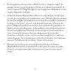
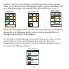
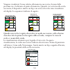
Press GOTO,
Select Street Route
0 .4 0
mi
Main
Airport
68
First A
v
e
Cow Creek
City Park
A
St.
Goto
Street Route
Point-to-Point
307
O
M
0.14
MI
Heading
Speed
Example:
Select Address
Los Angeles
Address
User Waypoint
Previous Destination
Roads
Railroads
Hydrography
Parks
Amusements
Find by
Alphabetical
A
H
G
F
E
D
C
B
I
P
O
N
M
L
K
J
Q
X
W
V
U
T
S
R
Y
6
5
4
3
2
1
Z
7
/
‘
.
-
0
9
8
Type Street Name,
(1st list choice appears)
Select Street
Fir_
Fire Island Road
CLEAR
OK
Add A Street Number
Within Range
Select Street
100
100-500
900-1000
First Avenue
San Jose, CA 97000
Accept
View
Select Street
307
O
M
0.14
MI
Bearing
Distance
Select Street
Fire Island Road, San
First Avenue, Glenvie
First Avenue, San Jo
West Fontana Avenu
West Fontana Street
Foundation Way, Oa
Fountain, San Gabri
San Jose
Street Route Active
0 .4 0
mi
Main
Airport
68
A St.
0.14
MI
First A
v
e
Cow
Cre
ek
City Park
A S
t.
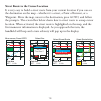
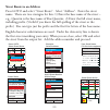
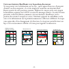
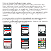
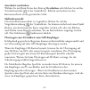
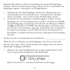
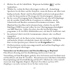
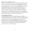
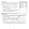
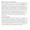
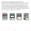
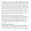
Street Route to an Address
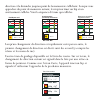
Press GOTO and select "Street Route". Select "Address". Enter the street
name. There are two strategies for this: 1) Enter the base name of the street –
e.g., Quentin is the base name of Rue Quentin; 2) Enter the full street name,
including prefix. (Useful if you know the full spelling of the street or the
prefix.) You can type just the prefix and the first few letters of the base name.
English character substitutions are used. Under the data entry line is shown
the first street matching your entry. When you are close, select OK and select
the street from the output list. Add the address number and proceed.
Summary of DirectRoute 3.0
Page 1
Mapsend ® directroute ™ quick start guide manuel de l’utilisateur benutzerhandbuch manuale dell’utente.
Page 2
© 2003 thales navigation, inc. All rights reserved. Magellan, mapsend, and directroute are trademarks of thales navigation..
Page 3: Magellan Mapsend Directroute
Magellan mapsend directroute quick start guide.
Page 5: The Product.
3 all global positioning system (gps) receiver products are navigation aids, and are not intended to replace other methods of navigation. Purchaser is advised to use good judgment in the use of this product. Read the user guide carefully before using the product. The mapsend directroute software is ...
Page 6
4 • the mapsend directroute database does not include, analyze, process, consider or reflect any of the following: legal restrictions (such as weight, height, width, load and speed restrictions); road slope or grade; bridge height, width, weight or other limits; population density; neighborhood qual...
Page 7: Magellan
5 magellan ® mapsend ® directroute ™ quick start guide overview mapsend directroute europe provides detailed navtech® street maps and points of interest for france, germany, austria, and switzerland. Mapsend directroute also includes basic, automated street routing and guidance functions. When you u...
Page 8: Basemaps Vs. Detailed Maps
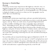
6 basemaps vs. Detailed maps basemap a basemap contains major map features like highways, railroads, cities, etc. Magellan mapping gps receivers have a built-in basemap. Basemaps have sufficient detail for orienting oneself to a broad geographic area. The basemap is displayed at higher zoom levels o...
Page 9: System Requirements
7 the unit switches automatically to a detailed map when a detailed map covers the majority of the displayed area,- and the zoom scale is 0.40 (700 meters) miles or closer. The detail map can be set to start appearing at higher or lower zoom levels on the unit by pressing the menu key, choosing map ...
Page 10: Installation
8 installation 1. With your computer on and all applications closed, insert the installation cd-rom into your cd-rom drive. 2. The installation application should begin automatically. Just follow the on-screen instructions to complete the installation. If installation does not start automatically, o...
Page 11: Toolbar
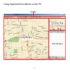
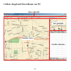
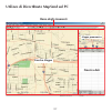
9 using mapsend directroute on the pc toolbar map window data window overview map.
Page 12: Toolbar
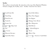
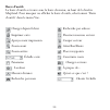
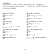
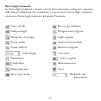
10 toolbar the toolbar is located under the menu bar at the top of the mapsend window. To hide or display the toolbar, select “toolbar” from the view menu. Search by address draw new region cut region manage street route place waypoints build route upload regions about what’s this overview scale mod...
Page 13: Overview Map
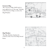
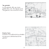
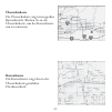
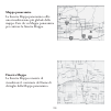
11 overview map the overview map window gives a more global view of the map. Clicking in the overview map re-centers the map window. Map window the map window displays the contents of the overview map’s detail frame..
Page 14: Data Window
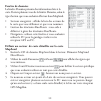
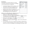
12 data window the data window presents information related to the map. There are several data window views, depen- dent on what you are trying to do in mapsend. • saved regions - lists regions of the map that you define and name. • street route management – helps you define and manage street routes...
Page 15: Panning Mode
13 panning mode from the tools menu choose pan, or click the pan tool on the toolbar. Click and drag the map to the desired location. Zooming mode to enlarge an area on the map, select the zoom in tool on the toolbar. You can simply click on the location in the map you want to enlarge, or you can cl...
Page 16
14 mapsend directroute is licensed for use with one gps receiver. When you upload a map you must assign the receiver’s serial number. There are two ways to do this- 1. Connect the gps receiver to the pc. Mapsend will automatically read the serial number from your gps receiver. You can use this metho...
Page 17
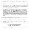
15 2. Click the upload regions button on the toolbar. 3. Choose where you want to send the map. Note: sending the map to the hard drive is useful if you wish to frequently switch maps on the unit. This option processes the map image and stores it, so next time you upload it you can skip the processi...
Page 18: Guidance On The Pc
16 the next two subsections describe routing and guidance on the pc. You may want to first read the next major section, using mapsend directroute on the gps receiver, before reading the following. Defining a street route on the pc start by selecting route management from the menu bar, or press f7 on...
Page 19: Viewing The Detailed Map
17 using directroute on the gps receiver viewing the detailed map there are two ways to quickly view a directroute map on the handheld. 1. Press the nav or esc key until you reach the map screen. Use the cursor key and the zoom keys to find the general area of the detailed map. You will see a rectan...
Page 20: Routing With The Goto Key
18 each time you create a street route on the gps receiver it becomes activated and ready to start guidance as soon as it is calculated. Only one street route can be active. A street route stays active until you deactivate it or you reach your destination– even if you power off and power up the unit...
Page 21
19 move cursor, press goto 0 .4 0 mi main airport 68 first ave 307 0.14 o m mi first a v e cow creek city park a s t. Select yes 0 .4 0 mi main airport 68 first ave 307 0.14 o m mi first a v e cow creek city park attention yes yes no go to first ave? A s t. Select street route 0 .4 0 mi main airport...
Page 22: Street Route to An Address
20 press goto, select street route 0 .4 0 mi main airport 68 first a v e cow creek city park a st. Goto street route point-to-point 307 o m 0.14 mi heading speed example: select address los angeles address user waypoint previous destination roads railroads hydrography parks amusements find by alphab...
Page 23: Guidance On The Gps Receiver
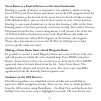
21 street route to a point of interest or previous destination routing to a point of interest or waypoint is very similar to address routing. Press goto, pick street route and choose one of the poi categories from the list. The window at the bottom of the screen lets you decide whether to show pois ...
Page 24
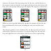
22 route list m i m park st 270 0.3 m i m destination 032 1.2 route list view m i m first ave 090 0.4 maneuver, the name of the upcoming street for the turn, and the distance to the maneuver point are shown. As you approach the next turn, the receiver will beep, and a turn prompt will pop up in the ...
Page 25
23 important : what if you miss a turn in directroute ? Directroute does not necessarily keep the position indicator icon on the road like some full navigation programs do. It also does not automatically re-route you, if you miss a turn. Sometimes the icon may be slightly away from the highlighted r...
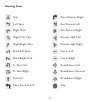
Page 26: Routing Icons
24 start left turn right turn slight left turn slight right turn hard left turn hard right turn u-turn left u-turn right forward enter freeway left enter freeway right exit freeway left exit freeway right freeway split left freeway split right stay to left stay to right roundabout left roundabout fo...
Page 27: Troubleshooting
25 troubleshooting if you do not see your detailed map, press the menu button on your magellan gps receiver and select “map utilities” and press enter. Highlight “change map” and press enter. Scroll down to highlight “detail map” and press enter. Select “detail00.Img” and press enter. If you do not ...
Page 28
26.
Page 29: Mapsend Directroute
Mapsend directroute manuel de l’utilisateur.
Page 31: D’Utiliser Ce Produit.
29 tous les récepteurs gps (système de positionnement global) de thales navigation constituent des aides à la navigation et ne sont pas destinés à remplacer les autres méthodes de navigation. Nous conseillons à l’acheteur de faire appel à son bon sens en ce qui concerne l’utilisation de ce produit. ...
Page 32
30 • il vous appartient de respecter le code de la route, y compris le respect des passages cloutés si vous êtes piéton, et de faire une utilisation raisonnable de votre récepteur gps magellan. Ignorez toute suggestion indiquant une route risquée, dangereuse ou illégale. • la base de données mapsend...
Page 33: Guide De Démarrage Rapide
31 guide de démarrage rapide mapsend® directroute™ de magellan® présentation générale mapsend directroute offre des plans de rues navtech® détaillés et des points d’intérêt pour la france, l’allemagne, la suisse et l’autriche. Mapsend directroute inclut également des fonctions de base automatisées p...
Page 34: Carte De Base
32 cartes de base et cartes détaillées carte de base une carte de base contient les principales entités cartographiques telles que les autoroutes, les voies ferrées, les villes, etc. Les récepteurs gps cartographiques magellan disposent d’une carte de base intégrée. Les cartes de base sont suffisamm...
Page 35: Autres Éléments Requis
33 sur la carte mémoire de l’appareil (ou utiliser un lecteur de carte sd pour enregistrer la carte directement sur la carte sd sans passer par le récepteur gps). L’appareil affiche automatiquement la carte détaillée lorsque celle-ci couvre la plus grande partie de la zone affichée et que l’échelle ...
Page 36: Installation
34 installation 1. Lorsque votre ordinateur est allumé et que toutes les applications sont fermées, insérez le cd-rom d’installation dans votre lecteur de cd-rom. 2. Le programme d’installation doit démarrer automatiquement. Il vous suffit de suivre les instructions à l’écran pour terminer l’install...
Page 37: Barre D'Outils
35 utiliser mapsend directroute sur pc barre d'outils fenêtre carte fenêtre données vue générale.
Page 38: Barre D’Outils
36 barre d’outils la barre d’outils se trouve sous la barre de menu, en haut de la fenêtre mapsend. Pour masquer ou afficher la barre d’outils, sélectionnez “barre d’outils” dans le menu vue. Recherche par adresse dessiner nouveau secteur couper secteur gérer rue/route placer waypoints construire ro...
Page 39: Vue Générale
37 vue générale la vue générale offre une vision globale de la carte. En cliquant sur la vue générale, vous recentrez la carte. Fenêtre carte la fenètre carte affiche de façon détaillée la trame qui est affichée dans la vue générale..
Page 40: Fenêtre De Données
38 fenêtre de données la fenêtre données présente des informations liées à la carte. Il existe plusieurs vues de la fenêtre données, selon le type d’action que vous souhaitez effectuer dans mapsend. • secteurs enregistrés : affiche la liste des secteurs de la carte que vous définissez et que vous no...
Page 41: Mode Panoramique
39 mode panoramique dans le menu outils, choisissez panorama ou cliquez sur le bouton pan- orama de la barre d’outils. Glissez-déposez la carte vers l’emplacement souhaité. Mode zoom pour agrandir une zone de la carte, cliquez sur le bouton zoom avant de la barre d’outils. Vous pouvez simplement cli...
Page 42
40 la licence qui accompagne mapsend directroute permet de l’utiliser avec un récepteur gps. Si vous chargez une carte, vous devrez lui assigner le numéro de série du récepteur. Pour cela vous pouvez soit : 1. Connecter le récepteur gps au pc. Mapsend lira automatiquement le numéro de série de votre...
Page 43
41 2. Cliquez sur le bouton téléharger secteur de la barre d’outils. 3. Choisissez l’emplacement sur lequel vous souhaitez enregistrer la carte. Remarque : il est recommandé d’enregistrer la carte sur votre disque dur lorsque vous changez fréquemment la carte chargée dans le récepteur. De cette faço...
Page 44: Guidage Sur Pc
42 définir un itinéraire rue/route sur le pc sélectionnez rue/route puis gérer à partir de la barre des menus ou appuyez sur f7 sur le clavier ou cliquez sur le bouton rue/route de la barre d’outils. La fenêtre gérer rue/ route s’affiche à droite de la fenêtre directroute. Le curseur se transforme e...
Page 45
43 1. Appuyez sur la touche nav ou esc jusqu’à ce que vous arriviez sur l’écran carte. Utilisez la touche de déplacement du curseur et les touches de zoom pour trouver la zone qui orrespond à la carte détaillée chargée dans le récepteur (un rectangle indique la zone qui correspond à la carte détaill...
Page 46: Naviguer Avec La Touche Goto
44 À chaque fois que vous créez un itinéraire rue/route avec le récepteur gps, celui-ci est activé et la navigation routière peut commencer dès que la route est calculée. Vous ne pouvez activer qu’un seul itinéraire rue/route à la fois. Un itinéraire rue/route reste actif jusqu’à ce que vous le désa...
Page 47
45 déplacer curseur, appuyer sur goto 0 .4 0 mi main airport 68 first ave 307 0.14 o m mi first a v e cow creek city park a s t. Sélectionner oui 0 .4 0 mi main airport 68 first ave 307 0.14 o m mi first a v e cow creek city park attention yes oui non aller à first ave? A s t. Sélectionner rue/route...
Page 48
46 appuyer sur goto, sélectionner rue/route 0 .4 0 mi main airport 68 first a v e cow creek city park a s t. Goto rue/route point à point 307 o m 0.14 mi cap vitesse exemple : sélectionner adresse los angeles adresse wpt utilisateur dest. Précédente routes voies ferrées hydrographie parcs attraction...
Page 49: Précédente
47 créer un itinéraire rue/route vers un point d’intérêt ou une destination précédente la navigation vers un point d’intérêt ou un waypoint ressemble beaucoup à la navigation vers une adresse. Appuyez sur goto, sélectionnez rue/route et choisissez une catégorie de poi dans la liste. De nombreux poin...
Page 50
48 liste routes m i m park st 270 0.3 m i m destination 032 1.2 vue liste routes m i m first ave 090 0.4 direction et la distanche jusqu’au point de la manueuvre s’affichent. Lorsque vous approchez du point de maneuvre suivant, le récepteur émet un bip et un avertissement s’affiche. Voici la séquenc...
Page 51
49 important : et si vous manquez un changement de direction ? Directroute ne garde pas nécessairement l’icône signalant votre position courante sur la route comme le font certains programmes de navigation. De la même manière, le système ne vous réoriente pas automatiquement si vous manquez un chang...
Page 52: Icônes De Navigation
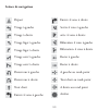
50 départ virage à gauche virage à droite virage léger à gauche virage léger à droite virage serré à gauche virage serré à droite demi-tour à gauche demi-tour à droite tout droit entrée 4 voies à gauche entrée 4 voies à droite sortie 4 voies à gauche ortie 4 voies à droite bifurcation 4 voies à gauc...
Page 53: Dépannage
51 dépannage si vous ne voyez pas votre carte détaillée, appuyez sur le bouton menu de votre récepteur gps magellan, sélectionnez “utilitaires carte” et appuyez sur entrée. Mettez en surbrillance “changer carte” et appuyez sur entrée. Faites défiler le menu jusqu’à “carte détaillée” et appuyez sur e...
Page 54
52.
Page 55: Magellan Mapsend Directroute
Magellan mapsend directroute benutzerhandbuch.
Page 57: Warnung
55 alle empfangsgeräte für das globale positionsbestimmungssystem (gps) sind navigationshilfen und nicht dazu gedacht, andere navigationsmethoden zu ersetzen. Der käufer sollte beim gebrauch dieses produkts umsichtig verfahren. Lesen sie vor der benutzung des produkts die gebrauchsanleitung sorgfÄlt...
Page 58
56 • die mapsend directroute-datenbank enthält keine einträge zu folgenden punkten und kann diese daher auch nicht analysieren, verarbeiten, berücksichtigen oder anzeigen: beschränkungen (z. B. Gewicht, höhe, breite, ladung oder geschwindigkeit); gefälle; durchfahrtshöhen, durchfahrtsbreiten, höchst...
Page 59: Kurzanleitung
57 magellan® mapsend® directroute™ kurzanleitung Überblick mapsend directroute europe bietet detaillierte navtech®-straßenkarten und points-of-interest für frankreich, deutschland, Österreich und die schweiz. Mapsend directroute unterstützt auch eine einfache und automatische routenplanung mit strec...
Page 60: Basiskarten Und Detailkarten
58 basiskarten und detailkarten basiskarte eine basiskarte enthält objekte wie autobahnen, bahnstrecken, städte usw. Magellan gps-empfänger mit kartenunterstützung verfügen über eine integrierte basiskarte. Basiskarten bieten genügend details zur orientierung in einem weiträumigen gebiet. Die basisk...
Page 61: Systemanforderungen
59 das gps schaltet automatisch auf eine detailkarte, wenn diese den größten teil des angezeigten gebiets abdeckt und ein maßstab ab 700 meter eingestellt ist. Sie können auch größere oder kleinere maßstäbe für die anzeige der detailkarte wählen. Drücken sie dazu die menütaste, wählen sie “kartenein...
Page 62: Installation
60 installation 1. Schalten sie den computer ein. Stellen sie sicher, dass alle anwendungen geschlossen sind und legen sie die installations-cd in das cd-rom- laufwerk ein. 2. Das installationsprogramm sollte automatisch starten. Befolgen sie die bildschirmanweisungen, um die installation abzuschlie...
Page 63: Symbolleiste
61 mapsend directroute am pc verwenden symbolleiste kartenfenster datenfenster Übersichtskarte.
Page 64: Symbolleiste
62 symbolleiste die symbolleiste befindet sich unter der menüleiste oben im mapsend- fenster. Klicken sie im menü ansicht auf "symbolleiste", um die symbolleiste ein- oder auszublenden. Suche nach adresse neue region zeichnen region ausschneiden straßenroute verwalten wegpunkte setzen route erstelle...
Page 65: Übersichtskarte
63 Übersichtskarte die Übersichtskarte zeigt einen großen kartenbereich. Klicken sie in die Übersichtskarte, um das kartenfenster neu zu zentrieren. Kartenfenster das kartenfenster zeigt den in der Übersichtskarte gewählten detailausschnitt..
Page 66: Datenfenster
64 datenfenster das datenfenster zeigt kartendaten an. Es gibt verschiedene ansichten des datenfensters, abhängig von der aktuellen aktion in mapsend. • “gespeicherte regionen” listet von ihnen auf der karte definierte und benannte regionen auf. • “straßenroutenverwaltung” hilft ihnen beim erstellen...
Page 67: Ausschnitt Verschieben
65 ausschnitt verschieben wählen sie im menü extras den eintrag verschieben oder klicken sie auf das verschiebesymbol in der symbolleiste. Klicken und ziehen sie den kartenausschnitt an die gewünschte stelle. Maßstabsauswahl um einen kartenausschnitt zu vergrößern, klicken sie auf das vergrößernwerk...
Page 68
66 mapsend directroute ist für die verwendung mit einem gps-empfänger lizenziert. Wenn sie eine karte übertragen, müssen sie die seriennummer des empfängers angeben. Dazu gibt es zwei möglichkeiten: 1. Verbinden sie den gps-empfänger mit dem pc. Mapsend liest die seriennummer des gps automatisch aus...
Page 69
67 2. Klicken sie auf die schaltfläche “regionen hochladen ” auf der symbolleiste. 3. Wählen sie, wohin die karte übertragen werden soll. Anmerkung: speichern sie die karte auf der festplatte, wenn die karten auf dem gerät häufig wechseln. Damit wird das kartenbild verarbeitet und gespeichert, so da...
Page 70: Streckenführung Auf Dem Pc
68 definieren einer straßenroute am pc beginnen sie mit dem befehl “routenverwaltung” in der menüleiste oder f7 oder über die schaltfläche straßenroutenverwaltung auf der symbolleiste. Das fenster straßenroutenverwaltung wird rechts neben dem directroute- fenster geöffnet. Der cursor wird zu einer g...
Page 71: Anzeigen Der Detailkarte
69 directroute auf dem gps-empfänger verwenden anzeigen der detailkarte sie können eine directroute-karte auf zwei arten schnell am handheld betrachten. 1. Drücken sie nav oder esc, bis die kartenseite angezeigt wird. Verwenden sie die cursortaste und die zoom-tasten, um die ungefähre position der d...
Page 72: Routenberechnung Mit Goto
70 bei jedem erstellen einer straßenroute auf dem gps wird diese aktiviert und kann sofort nach der berechnung mit der streckenführung beginnen. Es kann immer nur eine straßenroute aktiviert werden. Eine straßenroute bleibt solange aktiv, bis sie diese deaktivieren oder das ziel erreichen (auch über...
Page 73
71 cursor bewegen, goto drücken 0 .4 0 mi main airport 68 first ave 307 0.14 o m mi first a v e cow creek city park a s t. Wählen sie ja 0 .4 0 mi main airport 68 first ave 307 0.14 o m mi first a v e cow creek city park achtung yes ja nein first ave ansteuern? A s t. Straßenroute wählen 0 .4 0 mi m...
Page 74
72 drücken sie goto, straßenroute wählen 0 .4 0 mi main airport 68 first a v e cow creek city park a s t. Goto straßenroute punkt-zu-punkt 307 o m 0.14 mi kurs gschw beispiel: adresse wählen los angeles adresse anw-wegpkt. Letztes ziel straßen bahnstrecken hydrographie parks vergnügung suche nach al...
Page 75
73 straßenroute zu einem point-of-interest oder früheren ziel die routenplanung zu einem point-of-interest oder wegpunkt ist der zu einer zieladresse sehr ähnlich. Drücken sie goto, wählen sie straßenroute und anschließend eine poi-kategorie. Unten auf der seite können sie festlegen, ob poi alphabet...
Page 76
74 routenliste m i m park st 270 0.3 m i m ziel 032 1.2 anzeige routenliste m i m first ave 090 0.4 nächsten straße und die entfernung zum abbiegepunkt werden angezeigt. Wenn sie sich dem nächsten abbiegepunkt nähern, piept der handheld und eine abbiegeanweisung wird angezeigt. Das sieht zum beispie...
Page 77: Der Aktiven Route
75 wichtig: was geschieht, wenn sie einen abbiegepunkt verpassen? Directroute hält das positionssymbol nicht auf der straße, wie es einige echte navigationsprogramme machen. Auch erfolgt keine automatische routenneuberechnung, wenn sie eine abzweigung verpassen. Manchmal ist das symbol ein stück von...
Page 78: Routensymbole
76 routensymbole start links abbiegen rechts abbiegen leicht links abbiegen leicht rechts abbiegen scharf links abbiegen scharf rechts abbiegen wenden links wenden rechts geradeaus autobahnauffahrt links autobahnauffahrt rechts autobahnausfahrt links autobahnausfahrt rechts autobahngabelung links au...
Page 79: Problemlösung
77 problemlösung wenn keine detailkarte angezeigt wird, drücken sie die menütaste am magellan gps, wählen sie “karten-tools” und drücken sie enter. Markieren sie “karte wechseln” und drücken sie enter. Blättern sie bis “detailkarte” und drücken sie enter. Wählen sie “detail00.Img” und drücken sie en...
Page 80
78.
Page 81: Manuale Dell’Utente
Magellan mapsend direct route manuale dell’utente.
Page 83: Utilizzare Il Prodotto.
81 tutti i ricevitori satellitari di sistemi di posizionamento globali (gps) sono aiuti alla navigazione e non intendono sostituire altri sistemi di navigazione. L’acquirente è tenuto a fare uso del buon senso nell’utilizzare il prodotto. Leggere attentamente la guida dell’utente prima di utilizzare...
Page 84
82 • il database directroute mapsend non include, analizza, elabora, considera o riflette alcuno degli elementi che seguono: limitazioni legali (relative a peso, altezza, larghezza, carico e velocità); pendenza o inclinazione della strada; limitazioni concernenti altezza, larghezza, carico di ponti;...
Page 85: Guida Rapida
83 guida rapida magellan® mapsend® directroute™ panoramica ................................................................................................... 83 requisiti di sistema ....................................................................................... 85 installazione ...............
Page 86: Mappa Di Base
84 mappe di base e mappe dettagliate mappa di base una mappa di base contiene gli elementi topografici essenziali, quali autostrade, ferrovie, città e così via. I ricevitori gps con mappe magellan sono già comprensivi di una mappa di base incorporata. Le mappe di base sono sufficientemente dettaglia...
Page 87: Requisiti Di Sistema
85 con scheda inserita, è possibile connetterlo al pc ed effettuare il caricamento sulla scheda nell’unità, oppure utilizzare un dispositivo di scrittura/lettura su schede sd per caricare la mappa direttamente sulla scheda sd. L’unità passa automaticamente a visualizzare una mappa dettagliata quando...
Page 88: Installazione
86 installazione 1. A computer acceso e senza applicazioni attive, inserire il cd-rom di installazione nella relativa unità. 2. L’esecuzione dell’applicazione di installazione dovrebbe avvenire automaticamente. Seguire le istruzioni a schermo per completare l’installazione. Se l’installazione non si...
Page 89: Barra Degli Strumenti
87 utilizzo di directroute mapsend sul pc barra degli strumenti finestra mappa finestra dati mappa panoramica.
Page 90: Barra Degli Strumenti
88 barra degli strumenti la barra degli strumenti è situata sotto la barra dei menu, nella parte superiore della finestra mapsend. Per visualizzare o nascondere la barra degli strumenti, selezionare barra degli strumenti dal menu visualizza. Ricerca per indirizzo disegna nuova regione taglia regione...
Page 91: Mappa Panoramica
89 mappa panoramica la finestra mappa panoramica offre una visualizzazione più globale della mappa. Fare clic su mappa panoramica per centrare la finestra mappa. Finestra mappa la finestra mappa consente di visualizzare il contenuto del frame di dettaglio della mappa panoramica..
Page 92: Finestra Dati
90 finestra dati la finestra dati contiene le informazioni relative alla mappa. Sono disponibili varie viste della finestra dati, in base alle operazioni da compiere in mapsend. • regioni salvate - elenca le regioni della mappa definite e nominate. • gestione rotte stradali - consente di definire e ...
Page 93: Modalità Panoramica
91 modalità panoramica dal menu strumenti scegliere panoramica, oppure fare clic sullo strumento panoramica sulla barra degli strumenti. Fare clic e trascinare la mappa nella posizione desiderata. Modalità zoom per ampliare un’area sulla mappa, selezionare lo strumento zoom avanti dalla barra degli ...
Page 94
92 directroute mapsend è concesso in licenza per l’utilizzo con un solo ricevitore gps. Quando si effettua il caricamento di una mappa è necessario indicare il numero di serie del ricevitore. Questa operazione può essere eseguita in due modi: 1. Collegando il ricevitore gps al pc. Mapsend leggerà au...
Page 95
93 3. Scegliere quando inviare la mappa. Nota: l’invio della mappa al disco rigido è utile se si desidera passare frequentemente da una mappa all’altra sull’unità. L’opzione consente di elaborare l’immagine della mappa e di memorizzarla: in questo modo, il successivo caricamento avverrà più rapidame...
Page 96: Funzione Guida Sul Pc
94 definizione di una rotta stradale sul pc iniziare selezionando gestione rotte dalla barra dei menu, premendo f7 sulla tastiera, o facendo clic sullo strumento gestione rotte stradali sulla barra degli strumenti. La finestra gestione rotte stradali verrà visualizzata nella parte destra della fines...
Page 97
95 utilizzo di directroute sul ricevitore gps visualizzazione della mappa dettagliata esistono due modi per visualizzare rapidamente una mappa directroute sul dispositivo: 1. Premere il tasto nav o esc fino a raggiungere la schermata mappa. Utilizzare il tasto del cursore e i tasti zoom per individu...
Page 98
96 ogni volta che si crea una rotta stradale sul ricevitore gps, essa viene attivata e avvia la funzione di guida non appena terminate le operazioni di calcolo. È possibile attivare una sola rotta stradale per volta. La rotta stradale rimane attiva fino a quando viene disattivata o fino a quando si ...
Page 99
97 spostare cursore premere goto 0 .4 0 mi main airport 68 first ave 307 0.14 o m mi first a v e cow cre ek city park a s t. Selezionare sì 0 .4 0 mi main airport 68 first ave 307 0.14 o m mi first a v e cow cre ek city park attenzione yes sì no andare a first ave? A s t. Selezionare rotta stradale ...
Page 100
98 premere goto, selezionare rotta stradale 0 .4 0 mi main airport 68 first a v e cow creek city park a s t. Goto rotta stradale punto a punto 307 o m 0.14 mi direzione vel. Esempio: selezionare indirizzo los angeles indirizzo waypoint utente destinaz. Preced. Strade ferrovie idrografia parchi svago...
Page 101
99 calcolo di una rotta stradale verso un poi o una destinazione precedente il calcolo di una rotta verso un poi o un waypoint è molto simile al calcolo verso un indirizzo. Premere goto, scegliere rotta stradale e selezionare una delle categorie di poi dall’elenco. La finestra nella parte inferiore ...
Page 102
100 vengono visualizzati l’icona relativa alla manovra successiva, il nome della prossima via e la distanza al punto di manovra. Quando ci si avvicina alla svolta successiva, il dispositivo emette un bip e un avviso di svolta viene visualizzato sul display. La sequenza è indicata di seguito: rotta s...
Page 103: Rotte Attive
101 importante: cosa avviene se non si effettua una svolta indicata da directroute? Directroute non mantiene necessariamente l’icona dell’indicatore di posizione sulla strada, come avviene in alcuni programmi di navigazione completi. Inoltre, se l’utente non effettua una svolta prevista, la rotta no...
Page 104: Icone Di Calcolo Della Rotta
102 • nuovo goto – se si sposta il cursore dalla posizione corrente verso una nuova destinazione, mentre una rotta stradale è attiva, premere goto e selezionare nuovo goto dalla schermata soprastante per ricalcolare una nuova rotta, dalla posizione corrente alla nuova destinazione. Icone di calcolo ...
Page 105: Risoluzione Di Problemi
103 risoluzione di problemi se la mappa dettagliata non è visibile, premere il pulsante menu sul ricevitore gps magellan e selezionare utilità mappa, quindi premere invio. Evidenziare modifica mappa e premere invio. Scorrere verso il basso per evidenziare l’opzione mappa dettagliata e premere invio....
Page 106
104.
Page 108
Thales navigation consumer products z.A.C. De la fleuriaye b.P. 433 44474 carquefou cedex france tel: +33(0)2 28 09 38 00 fax: +33(0)2 28 09 39 39 631110-99b www.Magellangps.Com.

