- DL manuals
- Garmin
- GPS
- 400W-Series
- Pilot's Manual Addendum
Garmin 400W-Series Pilot's Manual Addendum
400W / 500W Series
Display Interfaces
Pilot’s Guide Addendum
• L-3 STORMSCOPE
®
WX-500 Weather Mapping
Sensor
• L-3 SKYWATCH
®
Traffic Advisory System
(Model SKY497)
• L-3 SKYWATCH
®
HP Traffic Advisory System
(Model SKY899)
• Bendix/King
®
KTA870 TAS/KMH880
Multi-Hazard Awareness System
• Ryan TCAD 9900B and 9900BX
Summary of 400W-Series
Page 1
400w / 500w series display interfaces pilot’s guide addendum • l-3 stormscope ® wx-500 weather mapping sensor • l-3 skywatch ® traffic advisory system (model sky497) • l-3 skywatch ® hp traffic advisory system (model sky899) • bendix/king ® kta870 tas/kmh880 multi-hazard awareness system • ryan tcad...
Page 2
This pilot’s guide addendum is written for: •garmingps400w,gnc420w/420aw,andgns430w/430awmainsystemsoftwareversions2.00,3.00,and later •garmingps500w&gns530w/530awmainsystemsoftwareversions2.00,3.00,andlater somedifferencesinoperationmaybeobservedwhencomparingtheinformationinthismanualtoearlierorlat...
Page 3
1 190-00356-31 rev. C caution: the global positioning system is operated by the united states government, which is solely responsible for its accuracy and maintenance. The system is subject to changes that could affect the accuracy and performance of all gps equip- ment. Although the garmin 400w/500...
Page 4: Table of Contents
2 table of contents section 1: introduction ...........................................3 section 2: l-3 stormscope interface ....................4 l-3 stormscope description ........................................ 4 power-up self-test ........................................................ 4 user-...
Page 5: Section 1: Introduction
3 section 1: introduction thegarmin400w/500wseriesunitsprovidethedisplayinterfaceandcontrolforthefollowingtrafficand weatherdevices/systems: •l-3stormscope ® wx-500weathermappingsensor •l-3skywatch ® trafficadvisorysystem(modelsky497) •l-3skywatch ® hptrafficadvisorysystem(modelsky899) •bendix/king ...
Page 6
4 section 2: l-3 stormscope interface l-3 stormscope description note: refer to the wx-500 pilot’s guide for a detailed description of the wx-500 stormscope. Thel-3stormscopewx-500weathermap- pingsensorisapassiveweatheravoidancesystem thatdetectselectricaldischargesassociatedwith thunderstormswithin...
Page 7
5 displaying storm data on the map page themappagedisplayscellorstrikeinformation usingyellowlightningstrikesymbologyoverlaid onamovingmap.Thisaddedcapabilityimproves situationalawareness,whichinturnmakesitmuch easierforthepilottorelatestormactivitytoairports, navaids,obstaclesandothergroundreferenc...
Page 8
6 190-00356-31 rev. C the strike data display phases are: 1. Lightning symbol (latest strikes; less than one minute; a black guard band is placed around the strike symbol during the first six seconds of display). 2. Large plus “+” sign (more than one minute old). 3. Small plus “+” sign (more than tw...
Page 9
77 190-00356-31 rev. C clearing the map page routinelyclearingthemappageofalldischarge pointsisagoodwaytodetermineifastormisbuild- ingordissipating.Inabuildingstormdischargepoints reappearfasterandinlargernumbers.Inadissipating stormdischargepointsappearslowerandinsmaller numbers. Clearing discharge...
Page 10
88 lightning page—400w series inadditiontothemappage,stormdatacanalsobeviewedonthelightningpage. Inthe400wseries,when thestormscopeisconnectedtotheunit,thelightningpageappearsafterthetrafficpageinthesequenceof navpages. Default nav map navcom position satellite status vnav traffic lightning terrain ...
Page 11
99 190-00356-31 rev. C lightning display thelightningpagedisplayseithera360°ora120° viewingangle.Innormaloperation,thecurrentstrike rateisdisplayedinthetoprightcorner,accompanied inthetopleftcornerbytheword“ltng”.Whenin strikemode,“strike”isdisplayedinthelowerright handcorneroftheweatherpageandwhent...
Page 12
10 10 190-00356-31 rev. C section 3: skywatch interface introduction withtheexceptionoftrafficdisplayrangeselec- tions,allinformationinthissectionpertainingtothe displayandcontrolofthel-3skywatch(sky497) alsoappliestothel-3skywatchhp(sky899)and thebendix/kingkta870/kmh880—thisincludes tcas-likesymbo...
Page 13
11 11 190-00356-31 rev. C to begin tracking intruder aircraft 1. Turn the cursor on and highlight stby. 2. Turn the small right knob to select oper. 3. Press ent to confirm operating mode and begin tracking intruder aircraft. Operating mode is confirmed by the display of “oper” in the upper right-ha...
Page 14
12 12 190-00356-31 rev. C altitude display mode the name of the selected altitude display mode (abv: look up, nrm: normal, blw: look down, or unr: unrestricted) is displayed in the upper left-hand corner of the traffic screen. The sky 497 continues to track up to 30 intruder aircraft within its maxi...
Page 15
13 13 190-00356-31 rev. C note: skywatch data is only displayed on the map page if suitable aircraft heading data is available. See the garmin 400w or 500w series installation manuals avail- able at your authorized garmin service center for details. Traffic page display range youcanchangethedisplayr...
Page 16
14 14 190-00356-31 rev. C thetopthreedatafields(topfourfieldsonthe500w series)ontherightsideofthemappage. When a traffic advisory is active, the “traffic” banner is displayed in the lower right corner of the map page. To display thumbnail traffic on the map page 1. Turn the small right knob to selec...
Page 17
15 190-00356-31 rev. C failure response errorsindicatedbya“failed”messageonthe screenpreventcontinueduseoftheskywatch. Pleaseseethel-3skywatchpilot’sguidefor detailedinformationonfailureresponse. Description of traffic advisory criteria foradescriptionoftrafficadvisorycriteriaand displayinterpretati...
Page 18
16 section 4: ryan tcad interface allinformationinthissectionpertainingtothedis- playandcontroloftheryan9900btcadalsoapplies totheryan9900bxtcadexceptforthefollowing: • tcas-like symbols are used in the 9900bx. Tcadsymbolsareusedwiththe9900b(seethe tableonpage17). • altitude modesareavailable(normal...
Page 19
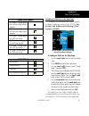
17 9900b (tcad) symbols trfc (white)—altitude separa- tion >500 feet, steady altitude separation ta (yellow)—altitude separa- tion £500 feet, steady altitude separation trfc (white)—altitude separa- tion >500 feet, closing pa (white)—altitude separa- tion £500 feet, opening trfc (white)—altitude sep...
Page 20
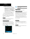
18 sideofthemappage. To display thumbnail traffic on the map page: 1. Turn the small right knob to select the map page. 2. Press menu to display the page menu. 3. Use the small right knob to select “change fields?” and press ent. 4. Select one of the top three fields (top four fields on a 500w serie...
Page 21
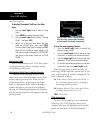
19 190-00356-31 rev. C ryan tcad setup page (9900b only) to change a tcad setup option: 1. Turn the small right knob to select the traffic page. Press menu to display the page menu. Turn the small right knob to select “setup?” and press ent. 2. The flashing cursor highlights the mode field. Turn the...
Page 22
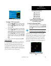
20 190-00356-31 rev. C to change the barometric pressure: 1. From the traffic page, press the cursor to highlight the operating mode field. Turn the large right knob to select the barometric pressure field. Use the small right knob to select the desired value and press ent. Note: when editing the va...
Page 24
©2008garminltd.Oritssubsidiaries garmininternational,inc. 1200east151 st street,olathe,kansas66062,u.S.A. Garminat,inc. 2345turnerrd.,s.E.,salem,oregon97302,u.S.A. Garmin(europe)ltd. Libertyhouse,bullscopseroad,hounsdownbusinesspark, southhampton,so409rb,u.K. Garmincorporation no.68,jangshu2 nd road...


